Are you interested? Read more - English texts are blue.
*
Interessieren Sie sich dafür? Deutsches Info in Rot.
*
Domina? Skaitykim toliau: liet. tekstai - juodomis raidėmis.
BRIUSELIS* BRÜSSEL* BRUSSELS* BRUXELLES
GRAND PLACEThe Grand Place or Grote Markt in Duch - central square of Brussel - is one of the most beautiful squares in Europe with architecture from 3 different eras (Baroque, Gothic and Louis XIV). It is a UNESCO World Heritage Site from 1998. Most of the buildings were rebuilt or restored in 1695.
 | ||||
| Panoramic view of Grand Place from left to right: The Museum of the City of Brussels, Guildhalls and the City Hall |
 |
| Grand Place by the night |
 |
| Grand Place: Museum, Guildhalls and City Hall |
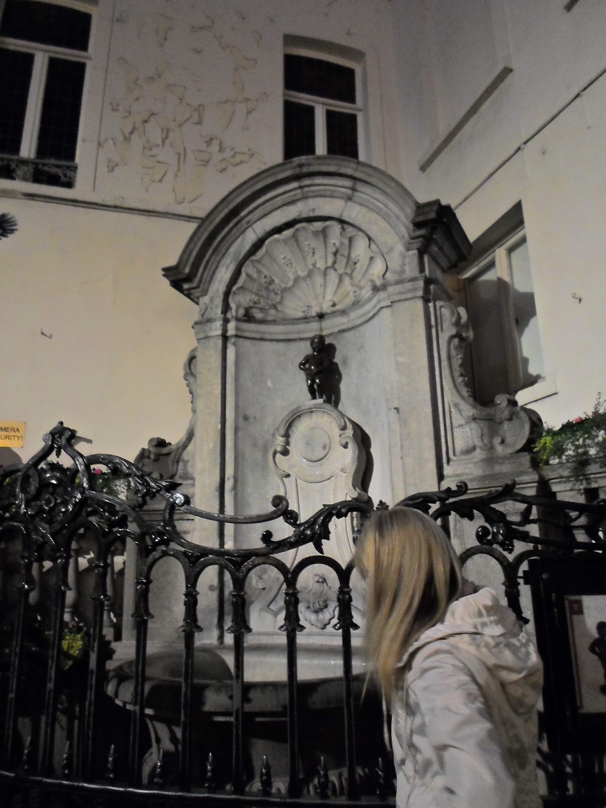 |
| Near Grand Place: Manneken Pis |
BRUSSELS: THE CAPITAL OF BELGIUM AND OF EUROPE
Brussels (Bruxelles) is a city with a population of about 1 million and home to institutions of EU and NATO. At the moment we didn't know more about Belgian capital because our PC was out of service and we couldn't search for information on the Internet. We parked our car next to the busses of city Sightseeing tours because we hoped to find here a map of Brussels. But it was wrong and we had to go to the tourist office at the Grand Place (central square of Brussels). At first we wanted to remember the street where we left our car: Boulevard del'Empereur / Keizerslaan. The name is very strange - isn't it? On the way to the Grand Place we understood that all the street names are in French and Dutch because Belgium is a bilingual country (its southern half is French and in the north is Flanders where people, known as the Flemish, speak Dutch). After visiting the tourist office for information we needed we could explore the historical city centre of Brussels.
The Grand Place (French) or Grote Markt (Dutch) is one of the most beautiful squares in Europe with architecture from 3 different eras (Baroque, Gothic and Louis XIV) giving it an eclectic flavour. It is one of the Sites of World Heritage by UNESCO since 1998. The central square of Brussels is surrounded by opulent guildhalls and two larger edifices, the city's Town Hall (French: Hôtel de Ville; Dutch: Town Hall Stadhuis), and The Museum of the City located in the Maison du Roi (French; "King's House") or Broodhuis (Dutch; Breadhouse "Brothaus"). Most of the buildings were rebuilt after the bombardment of Brussels by France in 1695. Historically, the Grand Place was a city centre and a market place since 11 century. Many streets surrounding the square are named after foods like chicken (poulet), herbs (herbes), cheese (fromage) etc. We took notice of street full of many people: RUE DE L'ETUVE (French) or STOOFSTRAAT (Dutch) that leads to the famous fountain with Manneken Pis. There were so many people that it wasn't possible to come nearer. We returned to our car and extended the parking time for another 2 hours.
Then we wanted to go from Boulevard de l'Empereur/ Keizerslaan up the monumental staircase toward the hill that is right above Brussels Old Town. All around smelt sweet because of Belgian waffles that were sold next to the Place Royale. We desided to visit the Royal Palace and the Parc de Bruxelles. Next to Royal Palace you find the Museum of Music Instruments, Margritte Museum, the Royal Museums of Fine Arts and that's why the hill is called Mont des Arts (that means Hill of Arts). The hill offers some of the finest views of Brussels and it is the second most important tourist destination (after Grand Place). The area of the Mont des Arts used to be a densely populated district. In the 19th century King Leopold II bought the hill to turn it to an art district but the project stood empty for years because of financial problems. 1956-58 there were built the Royal Library of Belgium and the Congress Palace. Next to this massive buildings is the beautifully landscaped square Place de L'Albertine with the statue of King Albert on horse. If the King would like to ride he could come direct to Grand Place.
It was the time to go to our hotel. In the afternoon we went to walk around the hotel and discovered the street Avenue Louise. It leads to the Place Poelaert with the Monument for Belgian and British soldiers (1914-1918 and 1940-1945). The Place Poelaert is located at the top of the Galgenberg (Mount of Strength), where you’ll find the Palace of Justice (French: Palais de Justice; Dutch: Justitiepaleis). These dominating edifices were built 1866-83 in the eclectic style by architect J. Poelaert. It is reputed to be the largest building constructed in the 19th century. The locals and tourists love this place because it provides one of the best views of Brussels (without having to climb on a building obviously!). Mont des Arts offers the finest view of Belgian capital but from the Place Poelaert you can see nearly the whole of the city. Wide views of Brussels make for a great starting point during your travels here. There are binoculars for visitors to use for looking down across the city. This panoramic view is dominated by the tower of the Town Hall and the Catholic church (French: Église de la Chapelle; Dutch: Kapellekerk) that is one of the oldest buildings of Brussels (founded 1134, built 13th century, restored 1866 and 1989). We could see even the Atomium (110 m high, built for the 1958 World Fair) in the distance. It is worth having a look at Brussels from Poelaert Place and enjoying the view on a beautiful sunset too. We looked over Old Town in front and wated untill the sun went down while the moon rose above the horizon behind us.
Brussels is divided into two parts (it reflects the lie of the land) and we were here at the border between the French Upper Town and the Flemish Lower Town with the main trading district and the Grand Place at its focus. It got dark but the night view from Place Poelaert was nothing special. We left the French part of Brussels and went down to the Flemish Old Town that surprised with its wonderful lighting buildings, especially on the Grand Place. Finally, we could come at the famous Manneken Pis fountain - but why the bronze figure is naked? He was dressed in the morning or I have seen something that was wrong? No, it's all O.K., the little boy really was clothed. It often happens because he has a collection of over 800 outfits... In the year 1698 the govenor of the Netherlands brought a gift to the city in the form of a blue woolen coat for the statue. This is tradition that continues today with visiting heads of state donating miniature versions of their national costume.
We went around the city chaotically - without guide and knowledge. But later it seemed as if a hand of one invisible guide-angel had led us at first to the Flemish Old Town with the Grand Place and then to French Upper Town with its major attractions - Mont des Arts, Palace of Justice, Royal Palace and the Cathedral of St. Michel (Gudula Church, 13-15th cent.). The first three we have seen, while the cathedral and other interesting attractions we hope to visit in the future...
It is between the Place Royale with the statue of Charles-Alexandre de Lorraine (near Palais Royale, Parc de Bruxelles, the Royal Museums of Fine Arts, the Musical Instrument Museum) and the Place de L'Albertine with the equestrian statue of King Albert I (near the city's Cathedral, Royal Library of Belgium, the Congress Palace)
 |
| The Palais Royal |
 |
| The Old Town and the spire of the City Hall seen from Place Royale |
 |
| Mont des Arts with the beautiful square and Place de L'Albertine; one of Brussel's finest views seen from Mont des Arts |
Die belgische Hauptstadt Brüssel (Bruxelles/ Brussels) zählt über 1 Mill. Einwohner und ist der Sitz von verschiedenen EU-Institutionen und NATO. Nur so viel wissen wir im Moment von Brüssel, weil unser Tablet außer Betrieb wird, wo wir alles vom Internet erfahren könnten. Wir parken unser Auto in der Nähe von touristischen SIGHTSEEING - Bussen in der Hoffnung da etwas von der Stadt zu erfahren. Aber das ist möglich nur im Infozentrum für Tourismus, das auf dem Zentralplatz Grand Place liegt. Bevor wir dorthin gehen, wollen wir uns die Straße merken, wo unser Auto parkt: Boulevard del'Empereur / Keizerslaan. Komischer Name, nicht wahr? Aber schon unterwegs zur Stadtmitte begreifen wir, dass alles in Brüssel doppel - niederländisch und französisch - genannt ist (denn Belgien ist ein bilinguales Land, wo im Norden Niederländisch und im Süden Französisch dominiert). Grand Place überrascht uns mit dem Spiel der Architekturlinien - später fällt mir ein, wie ich es nennen könnte: AJOUR! Wir müssen zuerst aber ins Infozentrum gehen, wo wir die Liste mit den Hotels, aber wenig Info von der Stadt bekommen. Auch ohne Brüssel-Kenntnisse sieht man, wie interessant sein historisches Zentrum ist, was später das Info vom Internet bestätigt: der Zentralplatz steht seit 1998 auf der Liste des Weltkulturerbes UNESCO. Der Grand-Place (frz.: Großer Platz) bzw. der Grote Markt (ndl.: Großer Markt) gilt mit dem gotischen Rathaus (frz.: Hôtel de Ville, ndl.: Town Hall Stadhuis), dem neogotischen Stadtmuseum (frz.: Maison du Roi - königliches Haus; ndl.: Breadhouse - Brothaus) und den Maisons des Corporations (ehem. Zunfhäuser) als einer der schönsten Plätze Europas. Die meisten Gebäude da sind nach dem Jahre 1695 gebaut worden. Die unterschiedlichen Architekturstile schaffen das originelle Eklektikflair, das die Touristen wie ein Magnet zieht.
Eigentlich war Grand Place als Marktplatz das Zentrum der Stadt bereits im 11. Jh. Er wurde auf einem trockengelegten Sumpfgebiet angelegt und lag 1,20 Meter tiefer als heute. Noch heute gibt es da Gassen mit den Namen der Lebensmittel: Geflügel (poulet), Pflanzen (herbes), Käse (fromage). Uns fällt die enge Gasse STOOFSTRAAT (ndl.) oder RUE DE L'ETUVE (frz.) auf, die besonders voll von Touristen ist und die - wundebar! - zum berühmten Brunnen mit Manneken Pis führt. Dass der Knabe der erklärte Liebling nicht nur der Brüsseler Bürger, sondern auch der Touristen ist, sieht man gleich: die Menschen drängen sich drumherum - ähnlich wie am Bild MONA LISA von Leonardo da Vinci in Louvre (Paris). Da es unmöglich ist an den Brunnen näher zu kommen, kehren wir zu unserem Auto zurück, um seine Parkzeit noch für 2 Stunden zu verlängern.
Danach aber entsteht der Wunsch eine breite Treppe hinauf auf den Berg zu gehen und so kommen wir zum Königlichen Platz (Place de Royal/ Koningsplein) mit einer Statue von Charles-Alexandre de Lorraine in der Mitte. Von hier sieht man sehr gut die Kirche Saint-Jacques-sur-Coudenberg mit ihrer strahlenden Fassade. Aber wir gehen in Richtung vom königlichen Palast, vorbei am großen Park (Parc de Bruxelles), wo belgische Waffeln verkauft werden. Ihr leckerer Geruch verbreitet sich am ganzen Berg, dessen eigentlicher Name Mont des Arts (Kunstberg) ist, denn hier sind zahlreiche Museen beheimatet (The Royal Museums of Fine Arts, Margritte Museum). Am Museum für Musikinstrumente, liegt eine wunderbar blühende Gartenterasse. Aber besonders beeindruckend ist hier die Aussicht hinunter in die Altstadt, deren Türme und Dächer ein subtiles Ajour-Muster bilden, in dem - natürlich! - der Rathausturm dominiert. Später erfahren wir, dass es eine der schönsten Aussichten von Brüssel ist und dass der Kunstberg am zweiten Platz in der Liste der touristischen Objekte liegt - nach dem Grand Place. Der Berg war eigentlich immer populär, deshalb kaufte der König Leopold II. dieses Territorium Ende 19. Jh. und fing mit der Einrichtung des Kunstbergs an - solange das Geld reichte. Später 1930 entstand hier eine Gartenanlage und 1956-58 wurde das Territorium mit massiven Gebäuden der Königliche Bibliothek (Royal Library of Belgium) und des Kongresspalastes (Congress Palace) bebaut. Die Gartenanlage grenzt an Place de L'Albertine mit der Statue vom König Albert in der Mitte. Er könnte direkt zum Grand Place reiten, denn von hier geht es hinab zum Stadtzentrum.
Wir aber gehen zu unserem Auto und fahren ins Hotel. In seiner Nähe entdecken wir am Abend Avenue Louise, die vorbei am kolossalen Justizpalast (gebaut 1866-83 im Eklektikstil) zum Poelaert-Platz führt. Auf dem Platz, der den Namen vom Architekten des Justizpalastes trägt, ist ein Denkmal mit den Daten 1914-1918 und 1940-1945 zu finden. Dahinten sieht man viele Menschen einen Sonnenuntergang beobachten - manche Jugendlichen sitzen sogar auf den Dächern. Auf dem Poelaert-Platz fangen die meisten Stadttouren an, nicht nur deshalb, weil hier die Fernröhre stehen, sondern weil sich von hier die beste Aussicht über die Stadt bietet. Sie ist nicht so schön wie vom Kunstberg, aber vollständig. Das Stadtbild beherrschen der Rathausturm und die katholische Kapellenkirche. In der Ferne sieht man sogar das für die Weltausstellung 1958 erbaute Atomium (110 m hoch und 2 500 t schwer), das im Norden der Stadt auf dem Messegelände steht. Die Kapellenkirche (ndl.: Onze-Lieve-Vrouw-ter-Kapellekerk; frz.: Église Notre-Dame de la Chapelle) ist eines der ältesten Gebäude in Brüssel (gegründet 1134, gebaut 13 a., restauriert 1866 und 1989).
Nicht nur Belgien, sondern auch Brüssel teilt sich in zwei Teile und wir sind hier an der Grenze zwischen der Oberstadt vom überwiegend französischen Charakter und der flämischen Unterstadt mit dem Hauptgeschäftsviertel, der Altstadt und dem Grand Place. Vorne geht die Sonne immer noch unter, während hinter uns über dem Militärdenkmal schon der Mond hängt. Es wird dunkel, aber die Nachtaussicht da ist nicht besonders. Wir verlassen das französische Brüssel und gehen hinab in die flämische Altstadt, die uns mit ihrem Licht- und Mondspiel überrascht, besonders - Grand Place. Endlich können wir an den berühmten Brunnen mit Manneken Pis kommen - warum ist die Bronzenfigur aber nackt? Am Tage hatte sie Kleider an oder ich habe was falsch gesehen? Nein, das passiert oft und der Knabe hat mehr als 800 Kostüme dazu... Die Gassen riechen immer noch nach Schokolade. Plötzlich öffnet sich ein Fenster im Obergeschoss des Hauses, worüber der Vollmond hängt: die lustige dreier Gesellschaft streckt ihre Köpfe heraus und fängt an zu singen... Die nun fröhliche Stadt hat eine komplizierte kosmopolitische Geschichte: Seine älteste Siedlung entstand um 580 auf der Senne-Insel; 1477 kam das Land an die Habsburger und unter Kaiser Karl V. wurde Brüssel Hauptstadt der spanischen Niederlande; 1830 nach der Vereinigung des Landes mit den Niederlanden wurde Brüssel die Hauptstadt des neuen Königreiches Belgien.
Wir sind durch die Stadt absolut chaotisch spazieren gegangen - ohne Reiseführer, ohne Kenntnisse. Wir gingen dorthin, wohin der Zufall führte. Später waren wir selber erstaunt, wie rationell unsere Routen waren. Es schien als ob die Hand eines unsehbaren Engels-Reiseführers gezeigt hätte, dass man mit der flämischen Altstadt und Grand Place anfangen muss. Dann sind wir absolut instiktiv zur französischen Oberstadt hochgestiegen, deren Sehenswürdigkeiten Kunstberg, Justizpalast, königliches Schloss und die Kathedrale St. Michel (Gudula Kirche, 13 - 15 Jh.) sind. Die ersten drei haben wir besichtigt, während die Kathedrale und die sehenswerte Zeremonie der Ablösung der royalen Schlossgarde und vieles mehr bleiben für das nächste Mal...
THE PLACE POELAERT
This square is located at the end of Avenue Louise at the top of the Galgenberg (Mount of Strength), where you’ll find National War Monument (1914-1918 and 1940-1945), the most important Court building in Belgium - the Palace of Justice (designed by the architect J. Poelaert) and the main attraction - nearly the whole view of the city. It makes for a great starting point during your travels here. There are binoculars for visitors to use for looking down across the city scape. It is worth enjoying the view on a beautiful sunset in Brussels
 |
| In the Palais of Justice (built 1866 -1883); on the right - Statue of Lycurgus of Sparta |
 |
| Place Poelaert: You could see the sunset at the front while at the back is the moon over monument |
 |
| Panoramic vew of Brussel from Poelaert Place from left to right: Catholic Church de la Chapelle (founded in 1134, restored in 1866 and 1989), Atomium (in the distance) and Town Hall |
Į BRIUSELĮ - BELGIJOS IR EUROPOS SOSTINĘ
Düsseldorfe, Vokietijoje, išsinuomuojame automobilį už 50 € dviem dienom ir nukreipiame navigaciją į Briuselį, tikėdamiesi pakeliui internete susirasti informaciją apie šį milijoninį miestą. Deja, planšetė išeina iš rikiuotės, o atmintyje - tik institucijų pavadinimai: ES komisija, ES taryba, Nato būstinė... Iš galvos išgaruoja net garsusis Briuselio Berniukas ar Briuselio kopūstas. Belieka dairytis po žalius Olandijos laukus, kurie yra pakeliui. Kadais keliavau po vakarinę Olandiją, tad atmintyje liko daugybė kanalų, kurie tuomet buvo apsėsti laikraščius skaitančių žvejų, sėdinčių ant patogių kėdučių. Ir Amsterdame pirmiausia įstrigo kanalai, o taip pat minios žmonių, per kurias teko irtis iki Van Gogo muziejaus. Tulpių neatsimenu, nes neliko laiko gėlių turgui. Tada - kaip ir šiandien - buvo šeštadienis, tad į Amsterdamą ne važiavome, o ropojome kamštyje. Šiandien keliai laisvi ir mes neužilgo jau - Belgijoje. Žibintų eilės liudija, kad belgų greitkeliai naktį apšviečiami.
Štai ir Briuselis: naviguojame link centro, o aš darausi ženklo TIC (Turizmo informacijos centras). Pravažiuojame stiklo pastatų kvartalą - tai įvairios ES institucijos, bet ženklo TIC nesimato. Pastebiu eilę turistinių autobusų su užrašu SIGHTSEEING - prie jų visada būna miestų žemėlapiai. Todėl netoliese pastatome automobilį ir užmokame už 2 val. (pigiau nei Vilniaus centre - tiesa, tik pirmąsias dvi valandas). Einame prie turistinių autobusų, bet ten nėra jokios informacijos, tad būtina eiti į senamiestį. Prieš tai dar reikia įsidėmėti gatvę, kurioje yra automobilis: Boulevard del'Empereur/ Keizerslaan - keistas dvigubas pavadinimas!? Vinguriuojant siauromis gatvelėmis pastebime, kad čia visi pavadinimai dvikalbiai: prancūziški ir olandiški (nes šalis, pasirodo, yra dvikalbė: šiaurinė - olandiška, pietinė - prancūziška). Pagaliau randame pirmąjį TIC, kur sužinome, kad pagrindinis TIC yra centrinėje aikštėje Grand Place. Jei eisi link tos aikštės pagal rodykles, tai apsuksi senamiestį kelis kartus. Geriau plaukti su žmonių srautu, nes jis (dažniausiai) juda į Grand Place. Aikštės architektūrinis derinys - neregėtas: tikras ažiūras! Bet pirma užeiname į TIC pasiklausti dėl nakvynės. Duodamas pluoštas lapų su viešbučių koordinatėmis - Briuselyje, matyt, yra taip (viešbutį sėkmingai susiradome centre, stebėtinai nebrangiai). Dabar galima gėrėtis istoriniu Briuselio centru. Vėliau internete sužinome, kad pagrindinė miesto aikštė nuo 1998 įtraukta į UNESCO paveldo sąrašą ir yra viena gražiausių Europoje. Grand-Place (pranc.: Didžioji aikštė) arba Grote Markt (oland.: Didysis turgus) apsupta įmantraus stiliaus Gildijų namais ir dviem įspūdingais pastatais: gotikine Rotuše (pranc.: Hôtel de Ville; oland.: Town Hall Stadhuis) ir neogotikiniu Briuselio istorijos muziejumi, kurį prancūzai vadina Karališkais rūmais (Maison du Roi), o olandai - Duonos namais (Breadhouse). Dauguma aikštės pastatų atstatyti po 1695 m. prancūzams sugriovius Briuselį. Trijų skirtingų epochų stiliai (barokas, gotika ir Louis XIV stilius) suteikia aikštei originalią eklektikos atmosferą, kuri kaip magnetas traukia turistus. Tiesą sakant, jau nuo 11 a. tai buvo centrinė miesto vieta, kur vykdavo turgus. Aikštė atsirado nusausintoje pelkėje - tuomet ji buvo 1,20 metro žemiau nei dabar. Aplinkui ir šiandien aptinkamos gatvelės, kurių pavadinimai susiję su maisto produktais: paukštiena (poulet), augalais (herbes), sūriu (fromage) etc. Prisivaikščioję po aikštę nutariame paėjėti siaura gatvele STOOFSTRAAT (oland.) arba RUE DE L'ETUVE (pranc.), kuri buvo tiesiog užkimšta turistais. Žmonių srautas atveda prie Briuselio berniuko, prie kurio neįmanoma prieiti - kaip prie Monos Lizos Luvre. Tad pasukame žaisminga gatvele link savo automobilio, nes baigiasi jo stovėjimo laikas. Pastatome jį jau kitoje vietoje ir vėl sumokame už 2 val.
Po to žmonių srautas nusineša plačiais laiptais į kalvą, į Karališkąją aikštę (Place de Royal), kurios centre ant žirgo didingai joja Charles-Alexandre de Lorraine. Iš čia gerai matosi saviti Saint-Jacques-sur-Coudenberg bažnyčios fasadai. Bet mes pasukame link Belgijos karalienės rūmų, praeiname didžiulį parką (Parc de Bruxelles), šalia kurio pardavinėjami garsieji belgiški vafliai, kurių kvapas sklinda po visą Karalių kalną, kaip mes jį vadiname iš pradžių. Vėliau paaiškėja, kad tai - Menų kalnas, kadangi čia - daug muziejų (The Royal Museums of Fine Arts, Margritte Museum). Terasoje prie Muzikos Instrumentų muziejaus groja muzikantai. Apačioje driekiasi gėlių skveras, toliau matosi senamiesčio panorama su rafinuotu bokštelių ažūru, kurio centre į dangų šauna Rotušės bokštas. Vėliau sužinosime, kad tai - viena subtiliausių Briuselio panoramų ir kad šis kalnas yra antras turistinis objektas Briuselyje - po Grand Place. Ši vieta visada buvo labai populiari. Todėl 19 a. pab. karalius Leopoldas II nusipirko šią teritoriją ir ėmė kurti Menų kalną, bet pritrūko pinigų. 1930 m. čia buvo įrengtas skveras, o 1956-58 jo teritorija apstatyta masyviais pastatais, tokiais kaip Karališkoji Belgijos biblioteka (Royal Library of Belgium) ir Kongreso rūmai (Congress Palace). Tuoj už skvero - Place de L'Albertine, kurios centre karaliaus Alberto I skulptūra - taip pat ant žirgo. Jei jis galėtų joti žemyn, patektų tiesiai į Grande Place. O mes jau sukame link savo mašinos (vėl baigiasi parkavimo laikas) ir vykstame į viešbutį. Šalia jo vakare aptinkame Luizos gatvę (Avenue Louise). Leisdamiesi ja praeiname galingus Justicijos rūmus (pilnus piktų antikinių skulptūrų) ir atkeliaujame į Poelaert'o aikštę, kuri pavadinta šių rūmų architekto vardu (tai buvo didžiausias 19 a. statinys Belgijoje, statytas 1866-1883 eklektikos stiliumi). Aikštės viduryje - paminklas su užrašais ant plokščių: 1914-1918 ir 1940-1945. Toliau pilna jaunimo, spoksančio į besileidžiančią saulę - kai kurie atsitupę net ant stogų. Čia briuseliečiai ateina palydėti saulės ir užbaigti darbo dienos, o turistai dažniausiai pradeda savo maršrutus. Kas nori detalesnio vaizdo, dairosi pro pastatytus žiūronus, bet ir be jų visas miestas iš čia - kaip ant delno. Vaizdas ne toks gražus kaip nuo Menų kalvos, bet užtat pilnas. Panoramoje išsiskiria Rotušės bokštas ir katalikiška Koplyčios bažnyčia, o tolumoje matosi net Atomiumas (110 m aukščio ir 2500 t svorio), pastatytas 1958 m. pasaulinės mugės proga. Na, o Koplyčios bažnyčia (oland.: Onze-Lieve-Vrouw-ter-Kapellekerk; pranc.: Église Notre-Dame de la Chapelle) yra vienas seniausių pastatų Briuselyje (įkurta 1134, statyta 13 a., restauruota 1866 ir 1989). Briuselis yra tarsi savo šalies atspindys, nes jis taip pat skirstomas į dvi dalis ir čia kaip tik esame ant ribos tarp prancūziškojo Aukštutinio miesto, kur dominuoja karališka menų dvasia ir flamandiškojo Žemutinio miesto su pagrindiniais prekybiniais kvartalais, senamiesčiu ir jo širdimi - Grand Place. Priekyje dar - saulėlydis, bet virš paminklo kariams, esančio už nugaros, jau kabo mėnulis. Pagaliau sutemsta, bet naktinis miesto vaizdas iš čia nėra ypatingas. Tad paliekame prancūziškąjį Briuselį ir leidžiamės nuo kalvos žemyn į flamandiškąjį senamiestį, kuris nustebina nuostabiu šviesų ir mėnulio žaismu, ypač Grand Place. Pagaliau galima prieiti ir prie fontano su garsiąja brozine berniuko figūrėle - bet gi dieną jis buvo apsirengęs ar man pasirodė? Ne, nepasirodė: tokie dalykai vyksta ir tam tikslui jis turi virš 800 kostiumų. Gatvelės vis dar kvepia šokoladu. Aukštai pro atvirą namo langą, virš kurio kabo mėnulis, linksma trijulės kompanija staiga iškiša galvas ir uždainuoja...
Nūnai linksmas miestas turi sudėtingą kosmopolinę istoriją: Briuselio seniausia gyvenvietė atsirado apie 580 m. Senne saloje; 1477 kraštas atitenka Habsburgams, o valdant kaizeriui Karlui V Briuselis tampa ispaniškųjų Nyderlandų sostine; 1830 m. susijungus šaliai su Nyderlandais Briuselis tampa naujosios Belgijos karalystės sostine. Vaikščiojome po šį miestą chaotiškai, be gido ir žinių, ėjome ten, kur traukė žvilgsnis. Bet kai vėliau perskaitėme informaciją apie Briuselį, nustebino mūsų maršruto racionalumas. Atrodo, kad kažkokia nematoma gido-angelo ranka rodė, kad reikia pradėti nuo flamandiškojo senamiesčio ir Grand Place. Po to panorome palypėti galingais laiptais, o jie atvedė į prancūziškąjį Aukštutinį miestą, kurio garsenybės - Menų kalnas, Justicijos ir Karališkieji rūmai, St. Michel katedra (Gudula Kirche, 13-15 a.). Pirmuosius apžiūrėjome, o štai miesto katedrai nebeliko laiko. Kaip ir karališkųjų rūmų gvardijos keitimosi ceremonijai ir daugeliui kitų dalykų - kitą sykį...
Šį kartą Briuselis iš karto patraukė ir įtraukė savo paslaugumu, kosmopolitine šurmuliuojančia minia ir dvasia, eklektinės ažūrinės architektūros vaizdais, šokolado ir vaflių kvapais. Briuselis nepaliko nė minutės laiko pasiruošti Luksemburgui, į kurį iškeliavome kitą dieną. Mintyse vis skambėjo du vaizdiniai: Liuksemburgo radijas ir Liuksemburgo sodai Paryžiuje (Jardin du Luxembourg). Jie abu susiję su laisve...
LIUKSEMBURGAS * LUXEMBOURG * LUXEMBURG
The history of Luxembourg begins with the acquisition of Lucilinburhuc castle situated on the Bock rock by Siegfried, Count of Ardennes, in 963. Many fortifications built here between 15th and 19th cent. were dismantled after 1867, but a network of underground caves, the Casemates Bock and Pétrusse, can still be seen. In 1994, the fortress remains and the city's old quarter were listed as a UNESCO worl Heritage Site. The highlights of the area are the spectacular views too, notably from the Place de la Constitution, Plateau du St-Esprit and the Chemin de la Corniche.
 |
| Place de la Constitution with the view over the building of Bank BCEE (1909); under the place are located Casemates de Pétrusse (17th cent.) |
I often remember the Radio Luxembourg that was far more than just a radio station. From its long-wave outset in 1933 to its final shutdown in 1992, Radio Luxembourg was not only the biggest commercial radio station in Europe. It was the expression of liberty for a whole generation in Western as well as Eastern Europe. In the Soviet times, we received it secretly to listen to music prohibited in Lithuania (for example, the "Beatles").
I like the Luxembourg Gardens in Paris too, but we were already in the real Luxembourg, officially in the Grand Duchy of Luxembourg. It is one of the smallest sovereign nations in Europe with area of 2,586 sq km and a population of 524,853 in the country and 100, 000 in its capital that colls Luxembourg too. Officially, the small country works in three languages, Luxembourgish (Lëtzerburgesch - dialect of German), French and German, however most people speak English as well!
The Navigation showed that we were already in the center of the capital but it wasn't true. We turned right and saw in a few minutes the place de la Constitution, which at the same time is a parking place for tourist buses and cars (free on Sundays) as well as a viewing point. There is enough space for the Monument to those who gave their lives in World War I too. High above the memorial is a golden figure of a woman, the Gëlle Fra, holding a wreath - a symbol of victory and she seems to hold it over the whole Luxembourg nation. The victory is personified very elegant, but the small state strategically placed between the powerful countries, Germany and France, definitely had to fight hard for his independence in 1839 (recognized in 1867).
The nature played an important role in city's life. The recorded history of Luxembourg began with the acquisition of Lucilinburhuc situated on the Bock rock by Siegfried, Count of Ardennes, in 963. The castle Lucilinburhuc, which gave the nation its name, was perched on a very steep rocky outcrop over two valleys (at a depth of 85 m) of the rivers Pétrusse and Alzette. It is somewhat of a natural fortification that once made Luxembourg an easily defensible stronghold. But unexpectedly the dukes of Burgundy occupied the city in 1443 and for next four centuries Luxembourg was ruled by the Burgundians, Austrians, Prusians. It was repeatedly reinforced as it passed from one great European power to another and was, from the 16th century until 1867, one of Europe's greatest fortified sites. The collapse of the German Confederation in 1867 led to an international crisis over Prussian's claim to Luxembourg. At the last moment the war was averted by the Treaty of London, under which the states agreed to guarantee Luxembourg's neutrality, but its fortress had to be demolished.
After 900 years the fortified city dismantled its walls and built the imposing bridges over deep valleys. In 1903 was opened the Adolphe Bridge (211 m long, 46 m high) and in 1966 - the Grande Duchesse Charlotte Bridge (355 m long). The first bridge (250 m long, 44 m high) over the Pétrusse river valley was completed in 1861. It connected the city on the Bock rock with Luxembourg railway station, opened in 1859 on the Bourbon plateau. Place de la Constitution offers a spectacular view over railway station quarter with iconic building (1909) of the Bank BCEE (French: Banque et Caisse d'Épargne de l'État - abbreviated short BCEE) as well as over the valley of Pétrusse and the Adolphe Bridge. There are underground fortifications - Casemates de Pétrusse too. We didn't know about that after our arriving, but we felt the fortress atmosphere of the city.
At first we wanted to visit a church that you could see from Place de la Constitution. It is the Cathedrale de Notre Dame built in 1613-18 by Jesuits and elevated to the status of cathedral in 1870 (extended in the 1930s). Nearby is the Place Guillaume (Wilhelmsplatz) with a statue of Grand Duke and King William II (r. 1840-49), the neo-classical Town Hall (Hôtel de Ville, 19th cent.) and the interesting view of old towers. We found there the Tourist Office where we obtained a city map that helped find an interesting old building with heraldic red lion as well as request in Luxembourgish: "Roude Léiw waach * Mir wölle bleiwe wat mir sin" ("Red lion be on the watch * we would like to be what we are"). In Luxembourg all was prepared for defence. We went past the massive civil buildings and gates of Old Town which looks like defensive structures and came unexpectedly to the free area with the view over the Passerelle. It is an old bridge over the river Pétrusse which flows into the river Alzette right behind the viaduct. The map from Tourist Office gave the information that Alzette's valley is a spectacular area with the old fortress which is well worth the time to take a stroll around. The Venceslas walk leads along the fortresses, protecting the city on one side and the fortress of the Raam plateau on the other. There you can find a lot of pubs, but if you go further away you see Bock Casemates. It is a network of underground fortifications with tunnels over a distance of 23 km, built in the 18th century. The Casemates included gun emplacement, munitions stores, stables and kitchens. It was also used as a bomb shelters for 35,000 people during Warl War II. By looking at the map it is clear, that other - Casemates de Pétrusse - (built in 17th cent.) are located under the Place de la Constitution which we visited one hour ago. It is tied to number the fortifications built here between 15th and 19th cent. and dismantled after 1867. A network of underground caves, the Casemates, can still be seen. In 1994, the fortress remains and the city's old quarter were listed as a UNESCO worl Heritage Site.
Luxemburg also has an undergraund city, but this spring day we didn't want to go into the dark caves (next time!). It is better to enjoy the city outside because the highlights of the area are the spectacular views too, notably from the Place de la Constitution, the Plateau du St. Esprit and the Chemin de la Corniche. After we left the view point and the fortified lanes we returned to the city quarter with the 18th -19th cent. buildings of refined elegance. Its centrepiece is the Grand Ducal Palace (built 1572, restored in 19th cent.). The Palace is open (only guided tours) for a period of 6 weeks over July and August whilst the Grand Duke and his family are away on their holidays. Just off the Palace is the Clairefontaine square with statue of Grand-Duchess Charlotte (1896-1985, r. 1919 -1964). Her son Jean reigned 1964-2000 and then he abdicated in favour of his son Henri. Grand Duke's Birthday (not the actual birthday of the current Grand Duke) the 23rd June is the country's national day.
It wasn't a festival day, but we heard A music, that led us to the Place d'Armes filled with tables and chairs from the surroundng cafes. At the centre of the square is the bandstand around which various concert seasons are based. The locals love this square of Old Town and it is a popular meeting place of the citizens of Luxembourg.
Next to the Place d'Armes is the main shopping street Grand rue or Groussgaas (pedestrian-only). At the end of the street you could find an intriguing fountain - Hämmelsmarschbrunnen (Sheep's March Fountain). The 2.80 metre tall well was made by sculptor W. Lofy in 1982 and represents a music band – an accordion player, a drummer, a tuba player and a horn player – together with sheep and two children holding an umbrella, protecting them from the “rain” and the water spurting out of holes in the sculpture. The Sheep's March "Hämmelsmarsch" traditionally opens the Schueberfouer – a yearly funfair towards the end of the summer. In days past, local music clubs would play the so-called mutton march and run a group of sheep through the city to invite to the fair.
Luxembourg is a modern city, but has strong links to the past. It is a crossroads as well as a meeting point of different cultures, which coexist harmoniously, making living in Luxembourg a unique experience. It was twice the European Capital of Culture - in 1995 and in 2007. Luxembourg was one of the six founding nations of the European Economic Community (1957), which evolved into European Union. Today, the city is the location for various EU institutions (European Court of Justice, European Court of Auditors, European Investment Bank etc.) and colls the third capital of Europe (after Brussels and Strasbourg). The famous "Gëlle Fra" from the Place de la Constitution seems to hold a wreath of victory over the whole Europe. It is really a big victory of one of the smallest independent nations in Europe strategically placed between the great European powers but saved its authenticity.
LUXEMBOURG - CITY OF IMPRESSING BRIDGES
The city is situated on the rock plateau between the valleys of the rivers Pétrusse and Alzette (depths up to 85 m) with the impressive old bridges over that.  |
| The Passerelle, also known as the viaduct or old bridge, over the Pétrusse river valley (built 1861); Church Église St Jean-Baptiste (17th cent.) standing in the district called Grund by river Alzette |
LUXEMBURG (LUXEMBOURG): DIE DRITTE EUROPÄISCHE HAUPTSTADT
Im Kopf klingt das Radio Luxemburg, das mehr als ein Radio war - das war Freiheit! In der Sowjetzeit haben wir es heimlich empfangen, um die bei uns verbotene Musik zu hören. Z. B.: die von "Beatles" oder das Lied von J. Lennon IMAGINE ("Stell dir vor: es gibt kein Himmelreich, keine Hölle, keine Länder - und die Welt lebt als eine")... Es gibt noch den Garten Luxemburg in Paris, aber wir kommen schon zum richtigen Luxemburg, zum Großherzogtum. Es ist einer der kleinsten europäischen Staaten mit der Fläche von 2.586 qkm sowie Einwonerzahl von 652.000 im Lande und 100 000 in der Hauptstadt, die auch Luxemburg heißt. Aber in so einem kleinen Land spricht man sogar drei Sprachen: Französisch, Deutsch und Luxemburgisch (Lëtzerburgesch - hochdeutsche Mundart)!
Die Navigation zeigt, dass wir schon im Zentrum der Hauptstadt sind, was nicht stimmt. Wir biegen nach rechts und in ein paar Minuten erscheint - unserer Meinung nach - eine Burg: da könnte die Stadtmitte sein! Vorne ist der Place de la Constitution, der zugleich ein Parkplatz für Touristenbusse und Autos (sonntags kostenlos) sowie ein Aussichtsplatz ist. Es gibt da genug Platz auch für das Mahnmal zum Gedenken an die im Ersten Weltkrieg verstorbenen Luxemburger. Hoch oben über den Mahnmal steht eine vergoldete Bronzestatue, die "Gëlle Fra", die in ihren Händen einen Lorbeerkranz hält, und es scheint, als halte sie diesen über die Luxemburger Nation. Der Sieg ist sehr elegant verkörpert, aber ein so so kleiner Staat unter den europäischen Großmächten musste hart für seine Unabhängigkeit kämpfen, die 1839 erklärt und 1867 anerkannt wurde.
Die Natur hat dabei bestimmt eine große Rolle gespielt. Denn die Stadt liegt auf dem mächtigen Bockfelsen, den Graf Siegfried I. im Jahre 963 mit der Burg Lucilinburhuc erwirbt. Damit legt er den Grundstein für die Stadt und das Großherzogtum Luxemburg. Von zwei bis 85 m tiefen Tälern sowie von der Stadtmauer umschlossen ist die Stadt lange unzugänglich. 1443 wird Luxemburg von Burgundern durch einen Überraschungsangriff eingenommen, in das Gebiet der Niederlande eingegliedert und dadurch in die Auseinandersetzungen zwischen den Valois-Bourbonen und den Habsburgern im 16.-19.Jh. hineingezogen. Vom 16. Jh. bis zum Jahre 1867 baut man hier immer wieder militärische Anlagen, bis die Stadt zu einer der wichtigsten Bollwerke Europas wird. Im Jahre 1867 wäre es beinah zum Krieg zwischen Deutschland und Frankreich wegen der Herrschaft über Luxemburg gekommen. Im letzten Moment wird es in der Londoner Konferenz zum ewig neutralen Staat erklärt. Bedingung: alle Befestigungsanlagen sollen geschleift werden.
Neun Jahrhunderte nach ihrer Gründung verliert die Stadt ihren Festungscharakter und fängt an Brücken über die fiefen Tälern zu bauen, die nun Liuksemburg ein Stadtbild von überraschender Schönheit verleihen. 1903 wird die Adolphe-Brücke (211 m lang, 46 m hoch), 1966 - Grande-Duchesse Charlotte oder Europabrücke (355 m lang) eingeweiht. Der erste Viadukt (250 m lang, 44 m hoch) über den Fluss Pétrusse entsteht 1861. Er verbindet die Stadt auf dem Bockfelsen mit dem 1859 gebauten Hauptbahnhof auf der felsigen Hochebene Bourbon. Vom Place de la Constitution öffnet sich ein atemberaubender Blick über das Bahnhofsviertel mit der Silhouette der BCEE (Staatsbank und Staatssparkasse), was wir für eine Burg gehalten haben sowie über das Pétrusse-Tal und die Adolphe-Brücke. Unter diesem Platz liegen Pétrusse-Kasematten. Davon wissen wir bei unserer Ankuft noch nicht, aber dass Luxemburg einen Festungscharakter hat, liegt hier einfach in der Luft.
Das hochragende Plateau Bourbon zieht wie ein Magnet, doch zuerst wollen wir die Kirche besichtigen, deren Türme vom Place de la Constitution zu sehen sind. Das ist Cathedrale de Notre Dame (ehem. Jesuitenkirche vom 17. Jh., seit 1870 Kathedrale, vergrößert 1935-38). Wir gehen dann Rue de la Congregation (frz.) oder Joffergässel (lux.) entlang und lesen mit Interesse die Doppelnamen der alten Gassen, die uns zum größten Platz der Stadt führt. Das ist der Place Guillaume oder Wilhelmsplatz mit dem Rathaus (Hôtel de Ville, 19. Jh.), dem Reiterstandbild des Großherzogs und Königs Wilhelm II. (Amtszeit 1840-49) und - einer wundervollen Aussicht auf die Türme der Altstadt! Da gibt es auch ein Infozentrum für Tourismus, wo wir einen Stadtplan erhalten.
Weiter werden die Gassen immer enger und die Mauern der Gebäude immer dicker. An einer Hausmauer sieht man das Wappen von Luxemburg mit dem roten Löwen und die Anschrift auf Luxemburgisch: "Roude Léiw waach * Mir wölle bleiwe wat mir sin". Um zu bleiben, musste man sich gut vorbereiten. Davon zeugen die mächtigen dreifachen Torlabyrinthen der Altstadt, die uns unerwartet zu einem Aussichtspunkt auf den alten Viadukt Passerelle über Pétrusse-Fluss führen. Hinter dem Viadukt mündet Pétrusse in den Fluss Alzette. Im Stadtplan steht, dass das Alzette-Tal einen Besuch wert ist. Einen Grund hierfür stellt der sogenannte Venceslas-Weg zwischen der ehemaligen Stadtmauer einerseits und den Befestigungen vom Raamfelsen andererseits, der zu Bockkasematten führt. Das ist ein Netz von 23 km langen Tunnels mit den Waffenlagern, Küchen Pferdeställen, angelegt unter der Erde im 18. Jh. Im 2. Weltkrieg dient es als Luftschutzbunker für mehr als 35000 Menschen. Vom Stadtplan wird klar, dass die anderen - Pétrusse-Kasematten (17. Jh.) - unter dem Place de la Constitution sind, wo wir vor kurzem waren. Vom 15. bis 19. Jh. werden in der Stadt auch mehrere Wehranlagen gebaut. Wegen des steten Wechsels der in Luxemburg anwesenden europäischen Mächte (Kaiser des Römischen Reiches, Burgunder, Habsburger, spanische und französische Könige und schließlich Preußen) kommen immer wieder andere Festungsbaumeister aus allen Himmelsrichtungen. Die Festungsanlagen - eine militärarchitektonische Zusammenfassung von mehreren Jahrhunderten und Kulturen - wurden bis 1867 benutzt, dann 1867-83 geschleift, aber die Kasematten sowie die anderen Überreste der Wehranlagen kann man auch heute besichtigen. Nicht nur die Militär- , sodern auch Zivilgebäude, die in einer atemberaubenden, natürlichen Umgebung entstanden sind, bilden den architektonischen Rahmen der Altstadt. Das ganze Ensemble erklärt die UNESCO 1994 zum Kulturerbe der Menschheit.
In Luxemburg gibt es also noch eine Stadt unter der Erde, aber an diesem Frühlingstag gibt es keinen Wunsch die zu besuchen (nächstes Mal!). Wir verlassen den Aussichtsplatz, die Gassen-Festungen und kehren zum geräumigen Stadtteil mit den Gebäuden des 18.-19. Jh. zurück. Am wichtigsten ist hier Palais Grand-Ducal, großherzogliches Schloß (Renaissancebau von 1572, restauriert im 19. Jh.). Wenn der Großherzog mit seiner Familie im Juli-August für 6 Wochen in Urlaub fährt, kann man das Schloss besichtigen, aber nur im Rahmen einer Führung. In der Nähe auf dem Place Clairefontaine steht das Denkmal für Großherzogin Charlotte (1896–1985, Amtszeit 1919-1964), deren Enkel Henri nun seit 2000 regiert. Der 23. Juni - der Geburtstag des Großherzogs (der nicht unbedingt mit dem Geburtstag des reagierenden Herzogs übereinstimmen muss) - ist Nationalfeiertag von Luxemburg. Die Musik, die am großherzoglichen Schloß zu hören ist, lockt uns zum Platz mit der Bühne in der Mitte, wo gerade ein Orchester spielt. Hier, im Place d'Armes, im zentralen Platz der Innenstadt, finden oft Konzerte statt. Umgeben von Cafés ist er gleichzeitig Treffpunkt für Einheimische. Nicht umsonst wird der Platz „Luxemburger Wohnzimmer“ genannt. Nicht weit vom Platz ist die wichtigste Geschäftsstraße und Fußgängerzone - Grand rue oder Groussgaas. Ein richtiger Fund da ist der Hämmelsmarschbrunnen, gestaltet 1982 vom Bildhauer W. Lofy. Das ist ein Ensemble aus vier frölichen Musikanten, an die sich Schafe und Kinder mit einem Regenschirm schmiegen. Der Schirm muss nicht nur vom Regen, sondern auch vom Brunnenwasser schützen, das aus mehreren Löchern des Denkmals sprudelt. Gemäß einem alten luxemburgischen Brauch zogen früher Musikanten zur Zeit der Kirmes mit einem Hammel über die Dörfer und spielten die Melodie des Hämmelsmarsches von M. Lentz.
Luxemburg ist eine lebendige Stadt mit menschlichen Dimensionen. Das ist ein Begegnungsort der Kulturen mit einer bewegten historischen Vergangenheit. Diese gekonnte Mischung ist einer der Bestandteile, die die Identität dieser Stadt ausmachen, die nicht umsonst schon zweimal Europas Kulturhauptstadt - im Jahre 1995 und 2007- war. Luxemburg gehört zu den ersten sechs Ländern, die im Jahre 1957 die Europäische Wirtschaftsgemeinschaft gründen, die sich später zur EU entwickelt. Auch heute befinden sich da der EU-Gerichtshof, der EU-Rechnungshof, ein Teil des EU-Parlaments etc., weshalb Luxemburg die dritte europäische Hauptstadt nach Brüssel und Straßburg genannt wird. Ist es nicht so, dass die berühmte "Gëlle Fra" auf dem Place de la Constitution ihren Siegeskranz nicht nur über Luxemburg, sondern über das ganze Europa halte? Immer unter den Großmächten zu sein, sich unter den verschiedensten Kulturen zu mischen, ohne seine Identität zu verlieren - ist es nicht ein SIEG? Ist es nicht das Radio Luxemburg?
OLD TOWN OF LUXEMBOURG CITY
There you'll will find the narrow medieval lanes, the Cathedral Notre-Dame (17th cent.), the Palais Grand-Ducal. On the Place Guillaume (Wilhelmsplatz) - the central square of Old Town - you could see a statue of Grand Duke and King William II, the neo-classical Town Hall. Just off the Place Guillaume is the Renaissance building - Grand Ducal Palace (restored during the nineties).
 |
| The lanes of the Old Tow |
 | |
| The gate of Old Town |
 |
| Vew of towers of Old Town from Place Guillaume (Wilhelmsplatz) |
 |
| Place Guillaume: statue of Grand Duke and King Wilhelm II |
 |
| A lane with heraldic lion and request to protect Luxembourg |
 |
| The Palais Grand-Ducal (1572) |
 |
| Bronze statue of Grand-Duchess Charlotte (1896-1985) in Clairefontaine square |
LIUKSEMBURGAS (LUXEMBOURG): TRČIOJI EUROPOS SOSTINĖ
Mintyse - Liuksemburgo radijas, kurį sovietų laikais gaudydavome norėdami pasiklausyti pas mus uždraustos muzikos (bitlų ar pvz. Dž. Lenono IMAGINE: "Įsivaizduok, nėra nei rojaus, nei pragaro, nei valstybių - visas pasaulis gyvena kaip viena šeima"). Tai buvo daugiau nei radijas, tai buvo laisvė! Kaip ir Liuksemburgo sodai Paryžiuje (aplankyti vos atsivėrus sienoms) su lengvutėmis kėdutėmis, kurias pasistatai, kur nori ir tada snaudi, skaitai, užkandžiauji ar tiesiog žiūri į gėles...
Bet mes jau atvykome į Didžiąją Liuksemburgo herzogystę ir vieną mažiausių valstybių Europoje. Tai - tiesiog lašas Europos aky: plotas 2.586,4 kv. km, gyventojų - 652.000; sostinėje, kuri taip pat vadinasi Liuksemburgas, gyvena apie 100 000. O štai oficialios kalbos šioje Vilniaus dydžio šalyje yra net 3: prancūzų, liuksemburgiečių (Lëtzerburgesch - kas moka vokiškai, supras šį vokiečių kalbos dialektą) ir vokiečių (mažai naudojoma).
Navigacija rodo, kad esame jau sostinės centre, ko realiai nėra. Sukame dešinėn ir už kelių šimtų metrų išnyra - mūsų manymu - pilies bokštai, o kur pilis, ten - centras. Tuo labiau, kad priekyje - Konstitucijos aikštė, kuri yra ir apžvalgos, ir turistinių autobusų, ir automobilių stovėjimo (sekmadienį nemokama!) aikštelė. Vietos lieka dar ir Gëlle Fra - paminklui I Pasaulinio karo aukoms atminti. Tai kolona su paauksuota moters statula, kuri laiko aukštai iškeltą lauro vainiką - tarsi virš visos Liuksemburgo nacijos. Pergalė įkūnyta elegantiškai, bet gyvenant tarp galingų valstybių, turbūt teko įnirtingai kautis dėl nepriklausomybės, kuri paskelbta 1839, pripažinta 1867.
Miestui tikrai padėjo gamta, nes jis įsikūręs ant galingos Bocko uolos, kurią 963 m. kartu su pilimi Lucilinburhuc nusipirko grafas Siegfriedas I. Tai buvo Liuksemburgo nacijos pradžia. Bockas iš trijų pusių apsuptas dviem 85 m gylio Pétrusse's ir Alzette's upių slėniais, o likusiąją dalį juosė gynybinė siena. Papildomai įtvirtinus miestą, jis nė karto nebuvo užimtas iki 1443 m., kai jį netikėtai užgrobė burgundai. Jie suteikė Liuksemburgui 1354 m. herzogystės statusą, bet pavertė jį Nyderlandų teritorija, kas tapo kivirčo priežastimi tarp karališkųjų Valua-Burbonų ir Habsburgų visą 16, 17 ir 18 a. Nuo 16 a. iki 1867 m. miestas buvo įtvirtinamas fortais ir kazematais, kol tapo vienu iš svarbiausiu gynybinių bastionų Europoje, dėl kurio 19 a. taip susikovė Prancūzija ir Vokietija, kad pakvipo karu. Paskutiniu momentu Londono konferencija 1867 m. Liuksemburgą paskelbė neutraliu miestu (amžiams!), bet jis privalėjo demontuoti įtvirtinimus.
Po 900 metų miestas nusimeta tvirtovės šarvus ir pradeda plėstis statydamas galingus tiltus virš gilių slėnių, kurie Liuksemburgui dabar suteikia nepakartojamo šarmo. 1903 m. pastatytas Adolfo tiltas (211 m ilgio, 46 m aukščio), 1966 m. - Didžiosios herzogienės Šarlotės arba Europos tiltas (355 m ilgio), o 1861 m. - pirmasis viadukas Passerelle (250 m ilgio, 44 m aukščio) per Pétrusse upės slėnį. Jis sujungė miestą ant Bocko uolos su geležinkelio stotimi, pastatyta 1859 ant taip pat įtvirtintos Burbonų uolos. Kaip tik iš Konstitucijos aikštės atsiveria įspūdingas šios teritorijos vaizdas, kuriame dominuoja Valstybės banko ir taupomosios kasos (BCEE) pastato siluetas, kurį palaikėme pilimi. Pastatas su bokštais stūkso ant uolos, apaugusios senais medžiais - kaip kokia Gedimino pilis. Stoties kvartalo apstatymas 19 a. laikomas sėkmės pavyzdžiu. Iš Konstitucijos aikštės galima pasižvalgytį ir po gilų Pétrusse's upės slėnį ir pasigrožėti Adolfo tiltu. Po šia aikšte randasi Pétrusse's kazematai. Vos atvykę to dar nežinojome, bet jausmas, kad tai buvęs miestas-tvirtovė, tiesiog tvyrojo ore.
Kaip magnetas traukė aukštai stūksanti Burbono uola, bet pirma nutarėme apžiūrėti bažnyčią, kurios bokštai matėsi iš Konstitucijos aikštės. Pasirodo, patekome į Liuksemburgo katedrą - Cathedrale de Notre Dame (buvusi Jėzuitų bažnyčia, nuo 1870 - katedra, statyta 1613-18, praplėsta 1935- 38). Po to sudomino Rue de la Congregation (pranc.) arba Joffergässel (liuks.), tada dar viena senamiesčio gatvelė: visos jos čia su dvigubais pavadinimais. Taip atvinguriavome į seniausią miesto aikštę - Place Guillaume arba Wilhelmsplatz su neoklasikine miesto rotuše (Hôtel de Ville, 19 a.), Didžiojo hercogo Wilhelmo II statula ant žirgo (valdė 1840-49) ir - labai gražiu senamiesčio bokštų vaizdu! Čia aptinkame turizmo infocentrą, kur gavę žemėlapį Liuksemburge pasijuntame kaip namie. Tad einame senamiesčiu toliau: gatvelės vis siaurėja (galvojame nebepralisime), o pastatų sienos vis storėja. Vienoje jų pastebėjome Liuksemburgo herbą (baltas fonas su mėlynom juostom ir raudonu liūtu centre) ir užrašą liuksemburgiečių kalba: "Raudonasis Liūte, būk budrus. Mes norime išlikti tuo, kas esame ("Roude Léiw waach *toliau herbas* Mir wölle bleiwe wat mir sin"). Kad išliktų, miestiečiai ne tik rašė, bet ir ruošėsi: kokie įspūdingi trigubi viduramžių senamiesčio vartų labirintai. Jei priešas prasimuš pro pirmus vartus, tai labai tikėtina, kad nepraeis pro antrus, ir tikrai užstrigs ties trečiaisiais. Bet prieš tai jam dar reikėjo praeiti galingus įtvirtinimus aplink miestą ir įkopti į uolas, kurias vėl pamatome pralindę pro vartų labirintus į apžvalgos aikštelę.
Priekyje žvilgsnį kaustė senasis viadukas Passerelle per Pétrusse upę, kuri tuoj už tilto įteka į kitą mažutį upeliūkštį Alzette. Žemėlapio informacijoje siūloma būtinai pasivaikščioti po Alzette's slėnį taip vadinamu Venceslas'o (Čekijos karaliaus ir Liuksemburgo herzogo) taku palei buvusią miesto sieną iš vienos pusės ir Raam'o uolos įtvirtinimus iš kitos. Dabar tai aludžių rajonas ir taip kilnojant bokalus (yra už ką!) galima ateiti iki Bocko kazematų, įrengtų 18a. Tai - 23 km tunelių tinklas su ginklų sandėliais, arklidėmis ir virtuvėmis po žeme. II pasaulinio karo metais nuo bombų čia slėpdavosi apie 35 000 žmonių. Iš žemėlapio paaiškėja, kad kiti - Pétrusse's - kazematai yra po Konstitucijos aikšte, kur ką tik buvome. Jie pastatyti 17 a, vėliau praplėsti, po 1867 užversti ir vėl atrasti 1933. Mieste gausu ir kitų gynybinių fortų ir bastionių, kurie buvo statomi nuo 15 iki 19 a., kol Liuksemburgas virto miestu-tvirtove. Per tą laiką čia valdė Romos imperijos kaizeriai, burgundai, Habsburgai, ispanų ir prancūzų karaliai, pagaliau prūsai. Keitėsi valdžia, keitėsi ir statybų meistrai, kurie atvykdavo iš visų kraštų. Šie gynybiniai statiniai - įvairių šimtmečių ir kultūrų karinis-architektūrinis lydinys - naudoti iki 1867, po to 1867-83 demontuoti, bet kazematus ir kitus įtvirtinimus galima apžiūrėti ir šiandien. Ne tik gynybiniai, bet ir civiliai statiniai, atsiradę naturalioje kvapą gniaužiančioje slėnių ir uolų panoramoje, suteikia senamiesčiui architektūrinį foną ir tarsi įrėmina jį. Visa tai nuo 1994 m. įtraukta į UNESCO pasaulio paveldo sąrašą.
Taigi, Liuksemburge yra dar vienas miestas po žeme, bet pavasarį nesinori lįsti į katakombas (kitą sykį!). Paliekame apžvalgos aikštelę, gatveles-tvirtoves ir grįžtame į erdvesnę dalį su 18-19 a. pastatais, kurių svarbiausias - renesansiniai Didžiojo herzogo rūmai (statyti 1572, restauruoti 19 a.). Liepą- rugpjūtį (6 sav.) herzogas su šeima išvyksta atostogauti ir tada visiems organizuojamos ekskursijos po rūmus. Netoli jų Clairefontaine aikštėje - paminklas Didžiajai Liuksemburgo herzogienei Šarlotei (Charlotte, 1896–1985), kuri valdė beveik visą 20 a. (1919-1964). Tada valdžią perdavė savo sūnui Jean'ui, o šis 2000 -savajam sūnui Henri. Birželio 23-oji - Didžiojo herzogo gimtadienis (kuris neturi sutapti su tuo metu šalį valdančio herzogo gimtadieniu) - yra Nacionalinė šalies šventė.
Jau prie herzogo rūmų girdimi muzikos garsai atvilioja į centrinę senamiesčio aikštę su scena viduryje, kurioje koncertuoja orkestras. Koncertai šioje Armijos aikštėje (Place d'Armes), apsuptoje kavinių, vyksta dažnai. Tai miestiečių mėgiama susitikimų vieta, dar vadinama "Liuksemburgo svetaine". Toliau gatvės dar labiau platėja ir mes jau esame pagrindinėje miesto gatvėje - Grand rue arba Groussgaas. Šioje pėsčiujų alėjoje atrandame ne tik garsiausias parduotuves, bet ir fontaną (1982 m.; skulpt. W. Lofy) su linksmais muzikantais (akordeonistu, būgnininku, dudoriumi ir rago putiku), aplink kuriuos šokinėja avytės ir vaikai, kurie dar sugeba išlaikyti skėtį. Tiek nuo lietaus, tiek nuo vandens čiurkšlių, trykštančių iš skulptūros kiaurymių. Pagal seną tradiciją, artinantis svarbiai Liuksemburgo šventei Kirmes, muzikantai traukdavo per kaimus vesdamiesi kartu aviną, grodami M. Lentz'o "Avino maršą" ir kviesdami visus į šventę. Akordeonistas - tai skulptoriaus autoportretas ir, esą jo pirštai rodo nepadorų žestą, skirtą miesto valdžiai, kurios jis tuo metu nemėgo.
Luksemburgui nesvetima viskas, kas žmogiška. Tai miestas, kuriame susilydę praeitis, kurioje daug kultūrų paliko savo pėdsaką, ir dabartis su naujų kultūrų sankirta. Šis tobulas lydinys yra vienas iš miesto identiteo bruožų, todėl neatsitiktinai Liuksemburgas jau 2 kartus buvo paskelbtas Europos kultūros sostine - 1995 ir 2007 (kartu su Sibiu iš Rumunijos). Jis buvo tarp pirmųjų 6 šalių, sukūrusių 1957 m. Europos Ekonominę Bendriją, iš kurios gimė ES. Ir dabar čia yra tokios institucijos kaip ES Audito Rūmai, ES Teisingumo teismas, dalis ES Parlamento etc. Miestas laikomas trečiąja Europos sostine po Briuselio ir Strasbūro. Taigi, garsioji Pergalės deivė Konstitucijos aikštėje Pergalės vainiką tarsi laiko ir virš visos Europos. Būti galingų valstybių ir kultūrų apsuptyje, be baimės nerti į jų būrį ir neprarasti identiteto - argi tai ne PERGALĖ ir laisvė? Argi tai ne Liuksemburgo radijas ar Liuksemburgo sodai Paryžiuje?
 |
| Sheep's March Fountain in the Grand Rue, Luxembourg's main shopping street |
Komentarų nėra:
Rašyti komentarą